


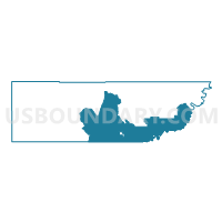
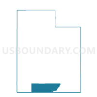
Church Wells Voting District, Kane County, Utah
About
Outline

Summary
| Unique Area Identifier | 678911 |
| Name | Church Wells Voting District |
| County | Kane County |
| State | Utah |
| Area (square miles) | 987.86 |
| Land Area (square miles) | 904.80 |
| Water Area (square miles) | 83.05 |
| % of Land Area | 91.59 |
| % of Water Area | 8.41 |
| Latitude of the Internal Point | 37.17440250 |
| Longtitude of the Internal Point | -111.58871300 |
Maps

Graphs
Select a template below for downloading or customizing gragh for Church Wells Voting District, Kane County, Utah


Neighbors
Neighoring Voting District (by Name) Neighboring Voting District on the Map
- Big Water Voting District, Kane County, UT
- Bullfrog Voting District, Kane County, UT
- Fredonia Voting District, Coconino County, AZ
- Glen Canyon Voting District, Coconino County, AZ
- Halls Crossing Voting District, San Juan County, UT
- Kanab 1 Unincorporated 2 Voting District, Kane County, UT
- Navajo Mountain Voting District, San Juan County, UT
- Page West Voting District, Coconino County, AZ
Top 10 Neighboring County Subdivision (by Population) Neighboring County Subdivision on the Map
- Kanab CCD, Kane County, UT (5,697)
- Blanding CCD, San Juan County, UT (4,904)
- Oljato CCD, San Juan County, UT (2,187)
- Kaibab Plateau CCD, Coconino County, AZ (2,037)
Top 10 Neighboring Place (by Population) Neighboring Place on the Map
Top 10 Neighboring Unified School District (by Population) Neighboring Unified School District on the Map
- San Juan School District, UT (14,746)
- Kane School District, UT (7,125)
- Fredonia-Moccasin Unified District, AZ (2,825)
Top 10 Neighboring State Legislative District Lower Chamber (by Population) Neighboring State Legislative District Lower Chamber on the Map
- State House District 3, AZ (216,687)
- State House District 2, AZ (177,904)
- State House District 73, UT (34,070)
- State House District 69, UT (31,813)
Top 10 Neighboring State Legislative District Upper Chamber (by Population) Neighboring State Legislative District Upper Chamber on the Map
- State Senate District 3, AZ (216,687)
- State Senate District 2, AZ (177,904)
- State Senate District 28, UT (94,905)
- State Senate District 27, UT (93,972)
Top 10 Neighboring 111th Congressional District (by Population) Neighboring 111th Congressional District on the Map
Top 10 Neighboring Census Tract (by Population) Neighboring Census Tract on the Map
- Census Tract 9782, San Juan County, UT (4,904)
- Census Tract 1301, Kane County, UT (2,297)
- Census Tract 9421, San Juan County, UT (2,187)
- Census Tract 20, Coconino County, AZ (2,037)